
|
 |
|
{Page 5}
Oklahoma Biological Survey and Department of Geography, University of Oklahoma, Norman, OK 73019-0575
Vegetation classification is an important tool for researchers and resource managers. In the case of wetland vegetation, there is a paucity of quantitative data and analysis for classification purposes. This study analyzed quantitative vegetation data from 55 sites in western Oklahoma. Eight vegetation classes were identified. The two most common vegetation types were dominated by Schoenoplectus americanus and Typha domingensis. Previous studies had not identified vegetation dominated by Heteranthera limosa-Bacopa rotundifolia-Marsilea vestita. One site was dominated by Thalia dealbata, which had not been reported from western Oklahoma in the past. © 2002 Oklahoma Academy of Science
| Introduction | Methods | Results | Discussion | References | Top of Page | Table of Contents | Home |
Information classification is a crucial aid in the interpretation of the relationships between categories (1). The classification of vegetation into units facilitates communication between researchers and resource managers (2,3). For wetland managers and researchers the Cowardin et al. (4) classification system has become an integral component of wetland inventory and conservation efforts (5). The goals set forth by Cowardin et al. (4) include (a) the description of ecological units with homogenous natural attributes, (b) arrangement of those attributes in order to aid resource managers, (c) identification of units for classification and inventory, and (d) provision of uniformity in concepts and terminology (5). At the base of the Cowardin et al. (4) classification are the dominance types which provide a description of vegetation units within a region.
Information on wetland dominance types for a region or state can be obtained through field studies or through a review of the published literature. Unfortunately, there is a paucity of literature regarding the vegetation of western Oklahoma herbaceous wetlands. The need for increased quantitative data for wetland vegetation in Oklahoma has been noted (6). Recent studies of western Oklahoma wetlands do not provide a classification of dominance types (7,8). Penfound (9) recognized 27 wetland vegetation types in western Oklahoma in a study of vegetation associated with reservoirs and natural lakes. The results of this study were based presence/absence data but were not quantitatively analyzed.
The structure and dynamics of vegetation in buffalo wallows is probably the most extensively studied wetland habitat in western Oklahoma (10-14). Buffalo wallows are small-scale landscape features with low species diversity and with vegetation composed of primarily perennial wetland species (14). Vegetation structure of playa lake wetlands were analyzed by Hoagland and Collins (15), including sites in Texas and Cimarron Counties.
The goals of the current study were to provide a quantitatively derived classification and description of herbaceous wetland vegetation. Such a classification will be of value to wetland conservation and management efforts in Oklahoma.
| Introduction | Methods | Results | Discussion | References | Top of Page | Table of Contents | Home |
Study area: Study sites were located in 16 western Oklahoma counties (Fig. 1). Within the study area, latitudinal variation in temperature and longitudinal variation in precipitation combine to produce a south-
{Page 6}
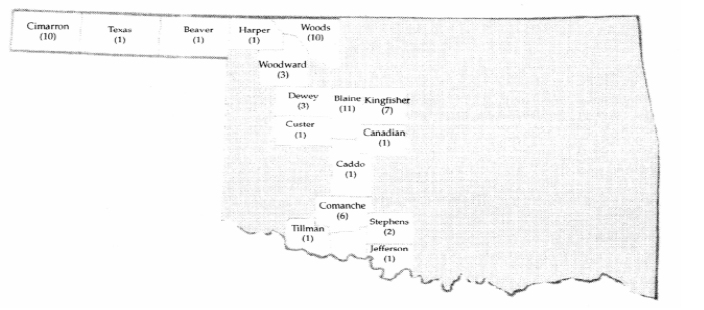
Figure 1: Location of western Oklahoma emergent wetland study sites. The number of sites quantitatively sampled in each is numerically designated.
east-to-northwest environmental gradient (16). For example, mean annual temperature in the southeastern portion of the study area is 17.2oC and in the northwest is 13.3oC (17). Likewise, the mean annual low temperature decreases from 18oC in the southeast to 1.7oC in Cimarron County, and the mean annual high temperature from 28.9oC to 25.6oC. There are 200 frost free days in Jefferson County as contrasted with 170 days in the northwest (17). Mean annual precipitation ranges from 83 cm to 41 cm along a southeast to northwest axis.
Physiographically, the study is characterized by gently rolling topography with local occurrences of dissected hills. The surface geology is composed primarily of shallow-marine deposits (18). However, Tertiary sands, clays, and gravels are prominent in Ellis, Harper, and the Panhandle Counties (18). Several soil great groups are present in the study area, ranging from darkly colored loams and clay loams developed under mid and shortgrass prairies which are typical of the panhandle, to dark or dark-reddish clay and clay-loam developed under tall, mid, and shortgrass prairie which are prominent in the remainder of the study area (19). Stabilized and active sand dunes along major streams are another important group of soils. They are mostly brown and light brown loams and sands with clay lenses that support semi-permanently flooded habitats (19). Gypsum outcrops and saline springs produce soils that support halopyhtic vegetation (20-22). In excess of 40 hydric soil types have been identified in western Oklahoma (8).
Data collection and analysis: Study sites were located by review of 1:24,000 scale US Geological Survey topographic quadrangles and National Wetland Inventory maps. Sites were excluded from this study if they met any of the following criteria: (a) heavily grazed (i.e., vegetation cropped to less than 3 cm and trampled), (b) converted to exotic pasture grasses (i.e., Cynodon dactylon), (c) currently or recently in row crop production, or (d) evidence of extensive physical modification. In the field, sites were assigned to the appropriate class in the Cowardin et al. (4) system. Quantitative vegetation data were collected from acceptable sites using randomly placed 0.25 m2 quadrats. This sample size was chosen because of the small size and linear nature of many western Oklahoma wetlands. A larger sample size would increase the amount of upland vegetation in the quadrat. The number of quadrats sampled depended on the total area of the site. All species occurring within a quadrat were recorded, and percent cover was then visually estimated to the nearest 5%.
Vegetation data from each site were compiled into a matrix of mean species cover values-by-site. Vegetation data were classified into floristic associations by using two-way species indicator analysis (1,23). These data were subsequently analyzed by
{Page 7}
using detrended correspondence analysis (DCA; 24,25) to identify regional gradients and trends in species composition.
| Introduction | Methods | Results | Discussion | References | Top of Page | Table of Contents | Home |
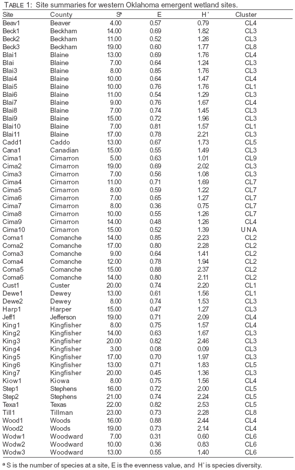
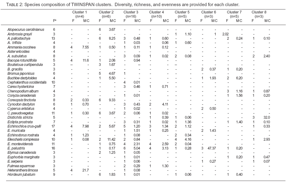
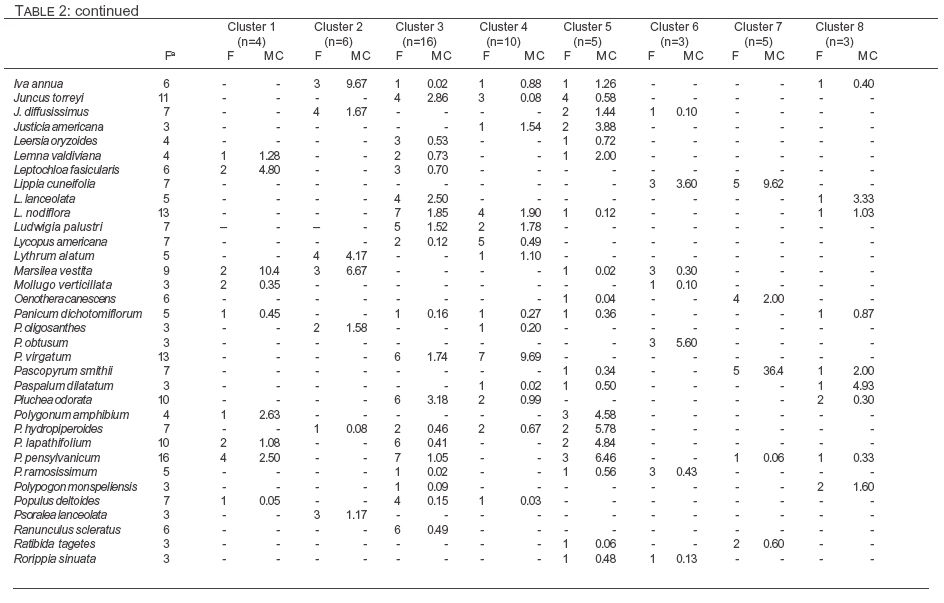
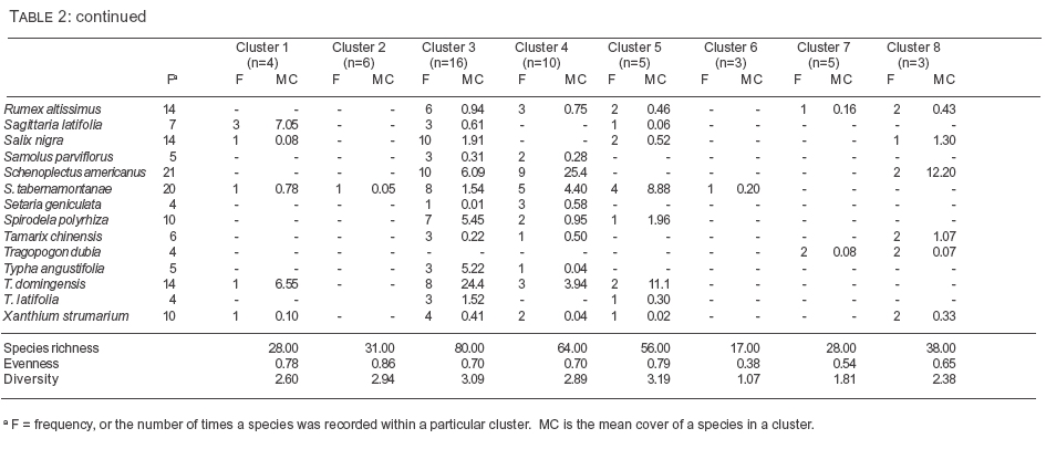
Vegetation classification: A total of 55 sites were sampled and 182 species encountered. The greatest number of sites where located in Blaine and Cimarron Counties. The distribution of sites reflects the availability and access to sites which met the sampling criteria. Table 1 lists all species encountered during the sampling, the TWINSPAN clusters into which they were classified, and species richness, diversity, evenness values for each cluster. TWINSPAN analysis produced eight vegetation clusters (Table 2). Echinochloa crusgalli, Eleocharis palustris, Polygonum pensylvanicum, Rumex altissimus, Schenoplectis americana, S. tabernaemontanii, and Typha domingensis were the most frequently encountered species. All vegetation clusters were dominated by perennial plant species.
Cluster 1 was composed of pond sites that occurred in the swales of stabilized sand dunes. These ponds and attendant vegetation were encountered throughout central Oklahoma, but not in far northwest Oklahoma or in the Panhandle. The dominance type at these sites was described as Heteranthea limosa-Bacopa rotundifolia-Marsilea vestita. Associated species included Ammania coccinea, P. pensylvanicum, P. coccinea, and Sagittaria latifolia. The most abundant plants on pond shorelines were Leptochloa fasicularis and E. crusgalli. Upland vegetation was dominated by Artemisia filifolia, Sporobolus cryptandrus, and Schizachyrium scoparium. Several swales throughout the study area contained this vegetation type, but were not sampled because of plowing.
Vegetation of Clusters 2 and 6 occupied small depressions on clay soils, and the dominant species in both were of the genus Eleocharis; E. compressa in the case of Cluster 2, and E. palustris in Cluster 6. Cluster 6 had both the lowest species richness (17) and species diversity value (1.07) of the TWIN-SPAN clusters. In both cases, upland vegetation was of the mixedgrass prairie dominated by S. scoparium-Sorghastrum nutans.
Cluster 3 contained the greatest number of sites and the highest species diversity. The greatest mean cover value and highest frequency was T. domingensis. Frequently co-occurring species included Lippia nodiflora, P. lapathifolium, P. pensylvanicum, Panicum virgatum, Salix nigra, and S. americanus. Sites for this vegetation occurred in a broad array of habitats, including palustrine and riverine.
Cluster 4 was dominated by S. americanus. Frequently occurring species included Cephalanthus occidentalis, Lycopus americana, P. virgatum, and S. tabernaemontanii. No clear vegetation type emerged from cluster 5. Species with high cover values in this cluster included one site dominated by Nelumbo lutea and two by Thalia dealbata.
Cluster 7 contained playa lakes. Pascopyrum smithii, a mesic C3 grass, was the dominant species at these sites. L. cuneifolia and Oenothera canescens co-occurred in all playa lake. Guymon playa, which captured irrigation run-off, was the only playa dominated by obligate wetland species (P. coccinea and P. lapathifolium).
Sites in Cluster 8 occurred in saline areas and were dominated by Distichlis stricta-S. americana. Frequently occurring species included Aster subulatus, E. palustris, and L. lanceolata. Boggy Creek salt flats, located in a gypsum outcrop area in Beckham County, a unique salt tolerant species, Cressa truxillensis, which had been previously documented from only one site in Oklahoma and not collected since the 1950 (26).
Ordination: Species turnover was lower on the first DCA axis (s.d. = 3.54) than the second DCA axis (s.d. = 6.71) (Fig. 2). Eigenvalues were high for both axes, 0.91 and 0.71, respectively. One site, the only site containing Phragmites australis, exerted a strong outlier influence and was excluded from analysis. The first axis represents a gradient of decreasing hydroperiod. Floristically, sites were separated by dominance of Typha spp. and/or Schoenoplectus spp. or grasses. Typha spp. and Schoenoplectus wetlands occur in semi-permanently flooded to permanently flooded conditions, while playa lakes, by comparison, were in-
{Page 8}
{Page 9}
{Page 10}
{Page 11}
{Page 12}
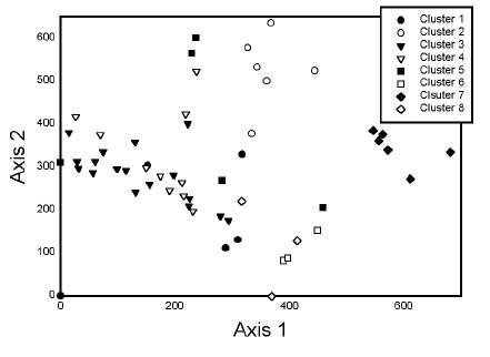
Figure 2: Detrended Correspondence Analysis biplot of emergent wetland sites in western Oklahoma. Sites are coded by Two-way Indicator Species clusters.
frequently flooded. Given the broad distribution to Typha spp. and Schenoplectus spp., neither axis represented a geographic gradient.
| Introduction | Methods | Results | Discussion | References | Top of Page | Table of Contents | Home |
Five of the seven vegetation associations correspond with the 29 vegetation associations listed by Penfound (9) for western Oklahoma; E. palustris, T. domingensis, S. americanus, N. lutea, and D. stricta. D. stricta vegetation is a dominant type at the Great Salt Plains (22). Several of the vegetation types listed by Penfound (9) represent stages in the annual hydrologic dynamics of wetlands. For example, six wetland types were listed for playa lakes: Lythrum-Verbena, Buchloë dactyloides, Chenopodium-Myosurus, P. persicaria, and Sida-Triticum. All of these species and genera, with the exception of Myosurus, were encountered to varying degrees of abundance, although none were dominants. B. dactyloides, which is capable of withstanding spring flooding (27), occurred in several of the playa lakes sampled for this study, but was not a dominant. It was reported as a dominant in playa lakes located in adjacent Texas and New Mexico (6).
Wetland vegetation dominated by members of the Cyperaceae, particularly the genus Eleocharis, have been reported from other studies. In this study, three of the vegetation types reported were dominated by the Cyperaceae. The genus Eleocharis is an important component of buffalo wallow vegetation (10 - 14,28). In western Oklahoma, Eleocharis species were most abundant in wet depressions or along shorelines. Only Penfound (9) reported vegetation dominated by S. americanus, which is interesting when its broad distribution in western Oklahoma is considered.
There were several sites dominated by broadleaf wetland plants. Nelumbo lutea, the most broadly distributed member of Nymph-aceae in Oklahoma, dominated one site. It has been reported as a dominant in other parts of Oklahoma (29,30). Interestingly, T. dealbata was the dominant at a Jefferson County site. The Atlas of the Flora of Oklahoma database shows the nearest population of T. dealbata to be located in Johnston County, making the Jefferson County station the westernmost in Oklahoma. Hoagland (6) reported the co-dominant species to be T. latifolia; however, in this study, Justicia americana was co-dominant.
This study demonstrates the diversity of vegetation in western Oklahoma emergent wetlands. However, further study is needed. The inclusion of aquatic vegetation as well as woody riparian vegetation is warranted. Although in many areas woody riparian wetland vegetation has been displaced by the Tamarix spp., stands of Salix nigra and S. exigua are extensive. Such efforts would complement this work by completing a classification of wetland vegetation.
Partial funding for this research was supplied by a grant from the Fish and Wildlife Foundation. The field assistance rendered by Newell A. McCarty, Debby Benesh, Sudeep Chandra, Carter Miller, and Stephanie Love is greatly appreciated.
| Introduction | Methods | Results | Discussion | References | Top of Page | Table of Contents | Home |
1. Gauch HG. Multivariate analysis in community ecology. New York (NY): Cambridge University Press; 1982. 298 p.
2. Mueller-Dombois D, Ellenberg H. Aims and methods of vegetation ecology. New York (NY): John Wiley and Sons; 1974. 350 p.
3. Bailey RG. Ecosystem geography. New York (NY): Springer-Verlag; 1996. 188 p.
4. Cowardin LM., Carter V, Golet FC, LaRoe ET. Classification of wetland and deepwater habitats of the United States. Washington, DC.: US Fish and Wildlife Service; 1979. 103 p.
5. Cowardin LM, Golet FC. US Fish and Wildlife Service 1979 wetland classification: a review. Vegetatio 1995; 118:139-152.
6. Hoagland, BW. The vegetation of Oklahoma: a classification for landscape mapping and conservation planning. Southw Nat 2000;45:385-420.
7. Heitmeyer ME, Vohs PA. Environmental characteristics of Oklahoma wetlands. Stillwater (OK): Oklahoma State University Arts and Science Research Environmental Series; 1981. 143 p.
8. Stinnet DP, Smith RW, Conrady SW. Riparian areas of western Oklahoma. Tulsa (OK): US Fish and Wildlife Service and the Oklahoma Department of Wildlife Conservation; 1987. 80 p.
9. Penfound, WT. Plant communities of Oklahoma Lakes. Ecology 1953; 34: 561-583.
10. Collins SL, Uno GE. The effect of early spring burning on vegetation in Buffalo Wallows. Bull Torr Bot Club 1983; 110:474-481.
11. Polley HW. An analysis of vegetation in buffalo wallows in relation to environmental gradients [MS Thesis]. Norman (OK): University of Oklahoma; 1983. 79p.
12. Polley HW, Collins SL. Relationships of vegetation and environment in buffalo wallows. Am Midl Nat 1984; 112:178-186.
13. Polley HW, Wallace LL. The relationship of plant species heterogeneity in relation to soil variation in buffalo wallows. Southw Nat 1986; 31:493-501.
14. Uno GE. Dynamics of plants in buffalo wallows: ephemeral pools in the Great Plains. In: Bock JH, Linhart YB, editors. The evolutionary ecology of plants. San Francisco (CA): Westview Press; 1989. p 431-444.
15. Hoagland BW, Collins SL. Heterogeneity in shortgrass prairie vegetation: the role of playa lakes. J Veg Sci 1997;8:277-286.
16. Goodman JM. Physical environments of Oklahoma. In: Morris JW, editor. Geography of Oklahoma. Oklahoma City (OK): Oklahoma Historical Society; 1977. P 9-24.
17. Sutherland SM. Climate of Oklahoma. In: Morris JW, editor. Geography of Oklahoma. Oklahoma City (OK): Oklahoma Historical Society; 1977.
18. Branson CC, Johnson KS. Generalized geologic map of Oklahoma. Norman (OK): Oklahoma Geological Survey; 1979. 1 p.
19. Gray F, Galloway HM. Soils of Oklahoma. Stillwater (OK): Miscellaneous Publications, Volume MP-56; 1959. 65 p.
20. Ward PE. Salt springs in Oklahoma. OK Geol Notes 1960;21:82-85.
21. Ungar IA. Salt tolerant plants growing in saline area of Kansas and Oklahoma. Ecology 1966;47:154-155.
22. Ungar IA. Species-soil relationships on the Great Salt Plains of northern Oklahoma. Am Midl Nat 1968;80:392-406.
23. Hill MO. TWINSPAN. [A FORTRAN program for arranging multivariate data in an ordered two-way table by classification of the individuals and attributes]. Ithaca (NY): Cornell University; 1979.
24. Hill MO. DECORANA. [A FORTRAN program for detrended correspondence analysis and reciporical averaging]. Ithaca (NY): Cornell University; 1979
25. Hill, MO, Gauch HG. Detrended correspondence analysis, an improved ordination technique. Vegetatio 1980; 42:47-58.
26. Hoagland BW. Atlas of the Flora of Oklahoma. [Database]. Norman (OK): Internal database. Oklahoma Natural Heritage Inventory; 2001
27. Porterfield HG. Survival of buffalo-grass following submersion in Playas. Ecology 1945;26:98-100.
28. Barkley FA, Smith CC. A preliminary study of the buffalo wallows in the vicinity of Norman, Oklahoma. Proc OK Acad Sci 1933;14:47-49.
29. Blair WF, Hubbell TH. The biotic districts of Oklahoma. Am Midl Nat 1938;20:425 454.
30. Blair WF. Ecological relationships of the mammals of the Bird Creek region, northeastern Oklahoma. Am Midl Nat 1938;20:473-526.
Received: November 18, 2001; Accepted: May 31, 2002.